


If you take a look at a map or globe of the world, you may notice lines running east-west and north-south. These lines, known as longitude and latitude are essential concepts in geography and navigation.
The lines running east to west are known as lines of latitude. The lines running north to south are known as lines of longitude. (Related: How to Remember the Difference Between Latitude and Longitude)
What is Latitude?
While lines of latitude run across a map east-west, the latitude indicates the north-south position of a point on earth.
Lines of latitude start at 0 degrees at the equator and end at 90 degrees at the North and South Poles (for a total to 180 degrees of latitude). Therefore, the higher the value of degree of latitude, the closer it is to the North or South Pole.
Positive and negative latitude values
Everything north of the equator is known as the Northern Hemisphere and everything south of the equator is known as the Southern Hemisphere.
The four quadrants of latitude and longitude
A location’s latitude is expressed in degrees (°), minutes (‘), and seconds (“).
A positive latitude value indicates a location in the Northern Hemisphere, while a negative value indicates a location in the Southern Hemisphere.
What is the Distance Between Lines of Latitude?
Lines of latitude are called parallels and in total there are 180 degrees of latitude. The distance between each degree of latitude is about 69 miles (110 kilometers).
(Watch this video on YouTube: Latitude and Longitude)
What is a Parallel?
A parallel is a named line connecting all points along the same line of latitude.
For example, the 49th parallel marked part of the border between Canada and the U.S. that was negotiated by the United States and Britain as part of the Treaty of 1818:
It is agreed that a line drawn from the most northwestern point of the Lake of the Woods, along the 49th parallel of north latitude, or, if the said point shall not be in the 49th parallel of north latitude, then that a line drawn from the said point due north or south, as the case may be, until the said line shall intersect the said parallel of north latitude, and from the point of such intersection due west along and with the said parallel, shall be the line of demarcation between the Territories of His Britannic Majesty and those of the United States, and that the said line shall form the southern boundary of the said Territories of His Britannic Majesty, and the northern boundary of the Territories of the United States, from the Lake of the Woods to the Stony Mountains.
What are the Major Lines of Latitude (or Parallels)?
The five major parallels of latitudes from north to south are called: Arctic Circle, Tropic of Cancer, Equator, Tropic of Capricorn, and the Antarctic Circle.
On a map where the orientation of the map is either due north or due south, latitude appears as horizontal lines.
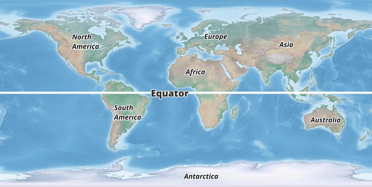
Where is the Equator?
The equator divides the earth into the Northern Hemisphere and the Southern Hemisphere is marks the location of 0 degrees latitude. Latitude represents an angular distance north or south of the equator.
The equator marks the locations on earth that are equidistance from the North and South Poles. The Equator is the only line of latitude that is a great circle, all the other lines of latitude are small circles. (Related: What is at Zero Degrees Latitude and Zero Degrees Longitude?). The equator crosses 78.7% water and 21.3% land and is about 24,901 miles (40,075 km) long.
The Original Definition of a Meter and the Equator
Here’s an interesting fact: the original definition of the length of a meter in 1793 was: one ten-millionth (10⁻⁷) of the distance between the equator and the North Pole along a great circle. The current definition of a meter is: the distance traveled by light in 1/299,792,458 of a second in a vacuum. (Source: Agnoli, P., & D’Agostini, G. (2004). Why does the meter beat the second?. arXiv preprint physics/0412078. arXiv:physics/0412078)
Where is the Tropic of Cancer?
The Tropic of Cancer marks the location where the sun reaches the zenith at this latitude. The exact latitude is not a fixed point and the latest measurement for 2014 is 23° 26′ 14.675″ (23° 26′ 16″). The summer solstice, which occurs on either June 20 or 21 of each year, marks the day on which the sun shines vertically over this parallel.

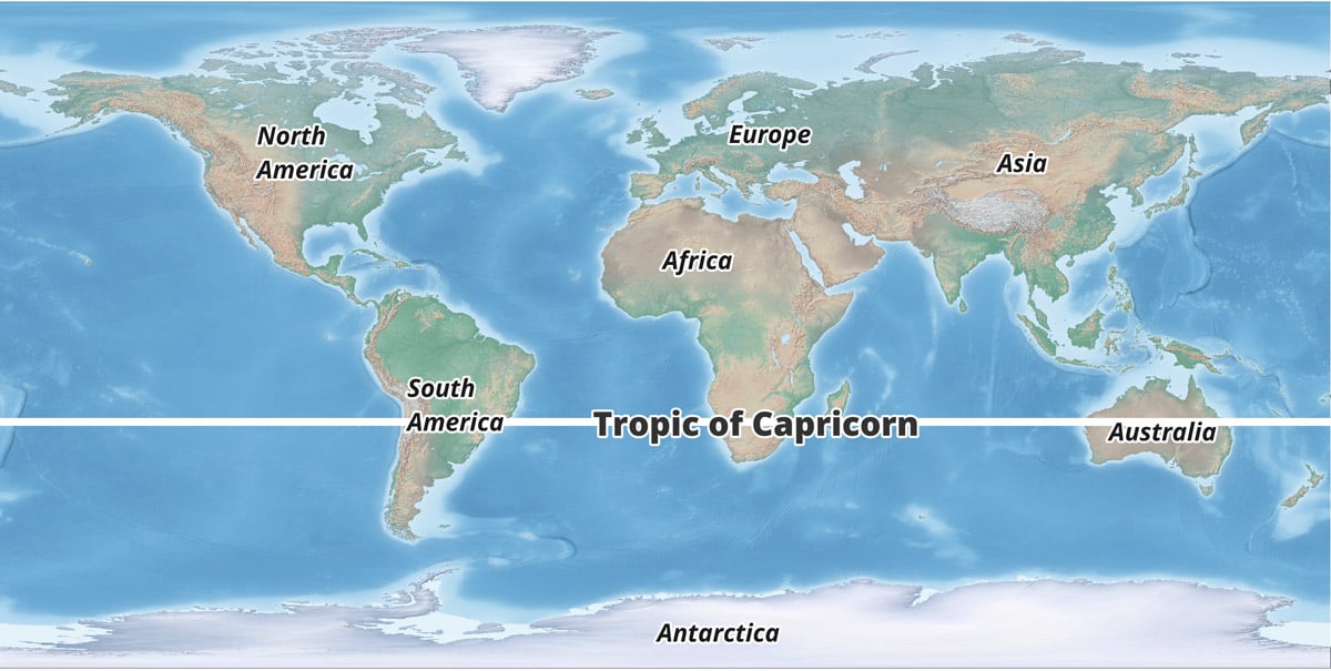
Where is the Tropic of Capricorn?
Moving every year, the Tropic of Capricorn is the parallel line of latitude that is currently located at 23° 26′ 14.440″. The winter solstice, which occurs on either December 21 or 22 of each year, marks the day on which the sun shines vertically over this line.
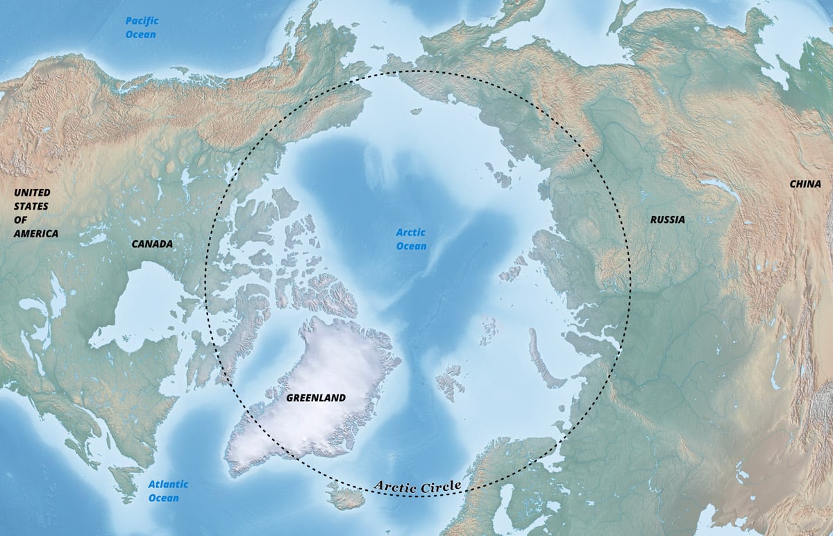
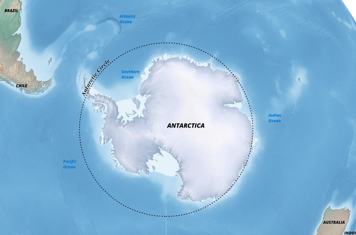
Where are the Arctic and Antarctic Circles?
The Arctic and Antarctic Circles are the parallels of latitude that are roughly 66.5 degrees (66° 33′ 44″ (or 66.5622°).
Arctic Circle
The region above the Arctic Circle, which includes the North Pole, is known as the Arctic.
Antarctic Circle
The region south of the Antarctic Circle, which includes the South Pole, is known as the Antarctic.
What are the Horse Latitudes?
The Horse Latitudes are found at about 30 degrees North and South of the equator. Horse latitudes represents areas in the subtopics where prevailing winds diverge and flow towards the poles (known as westerlies) or towards the Equator (known as trade winds).
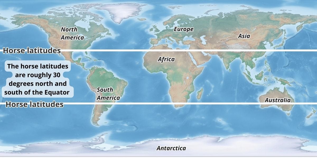
The horses latitudes are characterized by high atmospheric pressure, weak winds, and generally calm, stable weather conditions. These areas are known for their clear skies and low precipitation, which contributes to the formation of deserts at these latitudes, such as the Sahara Desert in Africa and the Mojave Desert in North America.
Legend has it that the calm winds would stall sailing ships at these latitudes for days or even weeks. In desperation, sailors would toss horses and livestock being transported to the Americas over board in an attempt to preserve drinking water supplies. This is the suggested origin of the phrase “horse latitudes”.
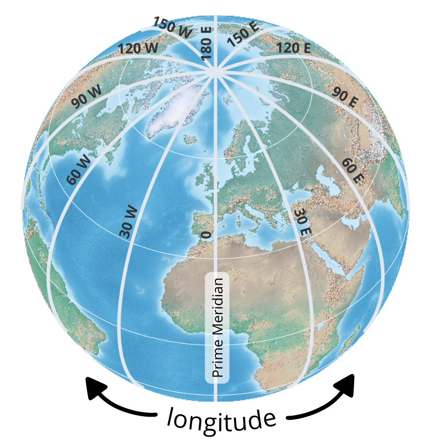
What is Longitude?
Longitude are lines that run north-south and mark the position east-west of a point. Therefore, latitude is the angular distance east or west of the Prime Meridian, which passes through Greenwich, England.
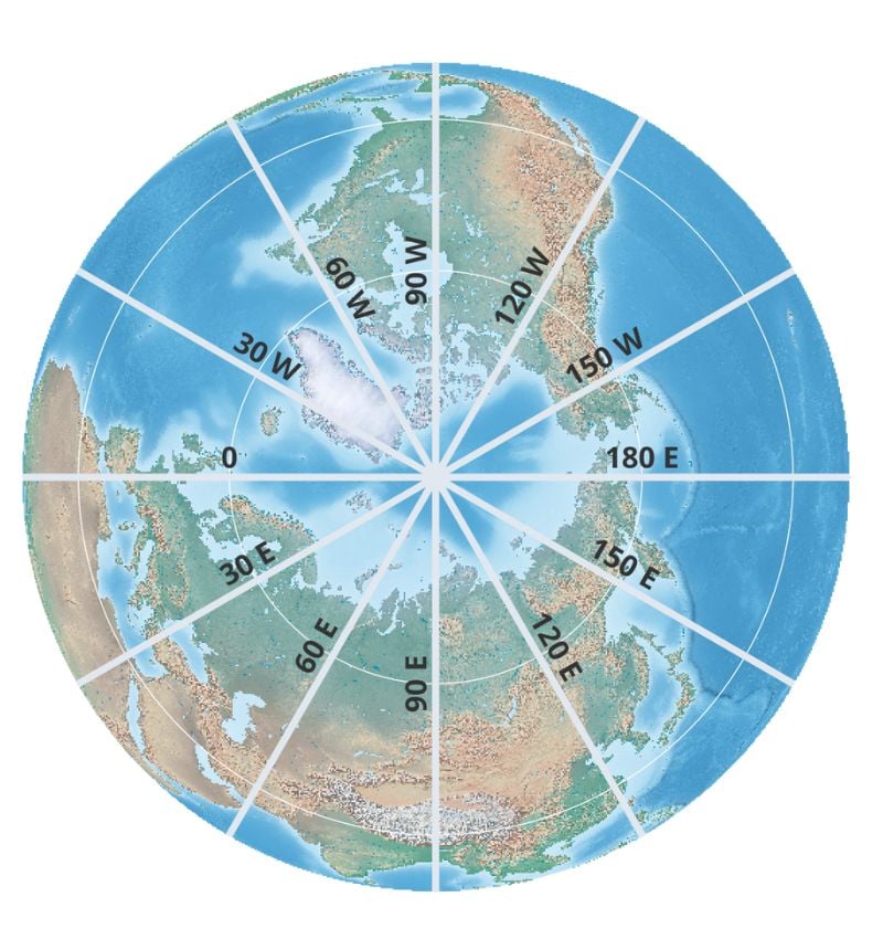
Lines of longitude run from pole to pole, crossing the equator at right angles. All lines of longitude are equal in length. Each line of longitude also is one half of a great circle.
Unlike lines of latitude, which run parallel to the equator, lines of longitude (meridians) converge at the poles. This means that the distance between lines of longitude decreases as you move towards the poles, making them closer together than they are at the equator.
Positive and negative longitude values
There are 360 degrees of longitude (+180° eastward and −180° westward.).
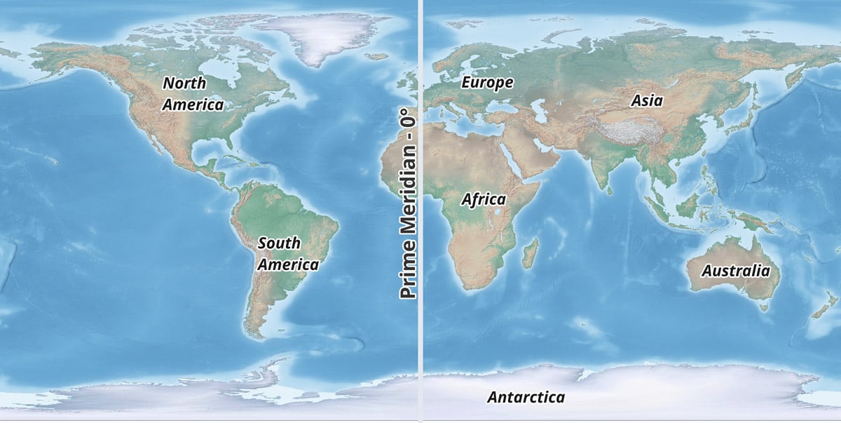
The longitude line of 0 degrees is known as the Prime Meridian and it divides the world into the Eastern Hemisphere and the Western Hemisphere.
A location’s longitude is expressed in degrees (°), minutes (‘), and seconds (“). A positive longitude value indicates a location in the Eastern Hemisphere, while a negative value indicates a location in the Western Hemisphere.
What is a Meridian?
While lines of latitude are known as parallels, lines of longitude are known as meridians.
How to Tell if a Meridian is East or West
Distances that that are west of the Prime Meridian are noted with a – in front of the number (negative numbers) and distances that are east of the Prime Meridian are positive numbers (-180 degrees degrees of longitude west and 180 degrees of longitude east).
What is the Distance Between Lines of Longitude?
The distance between longitudes narrows the further away from the equator. As you move toward the poles, the distance between each line of longitude becomes smaller until the converge at the North and South Poles.
The distance between longitudes at the equator is the same as latitude, roughly 69 miles. At 45 degrees north or south, the distance between is about 49 miles (79 km). The distance between longitudes reaches zero at the poles as the lines of meridian converge at that point.
Why was longitude so hard to determine until the 19th century?
Determining longitude accurately is crucial for navigation, particularly at sea. Before the development of accurate methods for measuring longitude, navigation, especially at sea, was an uncertain and perilous endeavor. Sailors could calculate latitude reasonably accurately by observing the sun or stars.
One degree of longitude corresponds to a specific distance on Earth’s surface, but unlike latitude, the exact distance varies depending on where it is measured. At the equator, where the Earth is widest, one degree of longitude is approximately 69.172 miles (111.321 kilometers). At the poles, all the lines of longitude converge, so the distance between degrees of longitude is negligible.
Historically, accurate timekeeping was the key to measuring longitude, as the difference in time between a known location (usually the Prime Meridian) and the local time at an unknown location could be used to calculate the east-west distance between the two points.
Determining local time was as easy as looking up at the sky to find the highest point of the sun which marked noon. Unfortunately, maintaining an accurate time for the home port was more challenging. Pendulum clocks onboard ships either ran too quickly, too slow, or not at all. An accurate clock that could withstand varying conditions of humidity, temperature, and pressure aboard a ship was needed.
Longitude Prize
In 1714, the British government established the Longitude Prize, which awarded £20,000 to anyone who could develop a practical method for accurately determining a ship’s longitude.
While no person collected the top prize during the Longitude Board’s tenure from 1714 to 1828, John Harrison, a British clockmaker, invented the marine chronometer. Harrison provided the first reliable watch that could maintain accurate time on long sea voyages. One of his prototype watches, called the H5, was tested by King George III and was determined to be accurate to within one third of one second per day.
The development of precise marine chronometers and, later, Global Positioning System (GPS), revolutionized the determination of longitude, making it easier for navigators and geographers to pinpoint locations on Earth.
Board of Longitude archives available online
The 300-year-old archive of the Board of Longitude has been scanned and made available to the public via the Cambridge Digital Library. More than 65,000 images have been scanned with the help of a £1.5m gift from the Polonsky Foundation.
What is the Prime Meridian?
The line of longitude where the degree is zero is known as the Prime Meridian. Passing through the Royal Observatory, Greenwich, England, it is also known as the Greenwich Meridian and divides Earth into two equal halves known as the Eastern Hemisphere and the Western Hemisphere.
Related: The Prime Meridian isn’t Where You Think it is
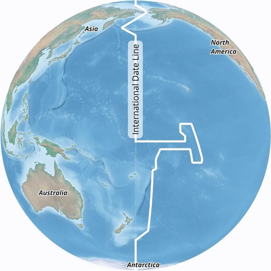
What is the International Date Line?
The line on Earth where one calendar day becomes the next is known as the International Date Line (IDL) which passes through the Pacific Ocean. The line is generally found 180 degrees from the Prime Meridian but the line circumvents some regions and islands to avoid dividing contiguous pieces of regions and countries into two separate days.
There are 23 one-hour slices and two 30 minutes slices that divide the world up into different time zones. Traveling from east to west over the International Date Line advances the calendar by one day. More: Geography of the International Date Line
How to Display Geographic Locations as Latitude and Longitude Coordinates
To provide a geographic location using latitude and longitude, a pair of numbers known as coordinates are used. Coordinates are composed of degrees, minutes, and seconds (DMS). When providing coordinates, Latitude is always written first. To provide the location of the United States Capitol building using latitude and longitude would be: 38° 53′ 35″ N, 77° 00′ 32″ W.
Decimal Degrees, which converts the minutes and seconds portion of the coordinates, is another way to write coordinates. In stead of noting the cardinal directions (N,S,W, or W) in decimal degrees, points that are west of the Prime Meridian and south of equator are preceded by a negative sign. Therefore, the United States Capitol’s coordinates (the absolute location) in decimal degrees are 38.889722°, -77.008889°.

Many mapping programs such as Google Maps use DD.
This article was first written on January 2, 2016 and has since been updated.
Fonte : National Geographic
, ”Per 2050 serve +50% olio, impossibile senza quello di palma”")
:”Semplicistica idea di risolvere problema eliminando un ingrediente”")
:”Certificazione olio di palma sostenibile è priorità per suo basso impatto”")


