


Heart shaped map projections are known as cordiform map projections. Cordiform is derived from the Latin “cor” for heart and “form” for shape.
What is the cordinform map projection?
Cordiform map projections are part of a broader family of map projections called pseudoconic map projections. Cordiform maps are characterized by their heart-like appearance, creating an aesthetically pleasing view of the world.
In a cordiform map projection, the meridians (lines running from the North to the South Pole) are typically curved, converging at the poles and spreading out towards the equator, while the parallels (lines running east-west) are straight but get closer together as they move away from the equator. This results in a map that is somewhat distorted towards the poles in order to bend the natural features of the Earth into a heart shape. Cordinform maps tend to preserve area (making them equal-area projections) but distort shapes, especially towards the edges of the map.
Cordiform projections were more popular in the 16th and 17th centuries among European cartographers. This type of map projection was used in maps promoting the growing knowledge of the world and the expanding horizons of European explorers.
In honor of Valentine’s Day, here’s a look at some historical maps using heart-shaped map projections. These maps illustrate how mapmakers have combined science, art, and symbolism to represent the then known world.
Werner Map Projection
The Werner map projection is a heart-shaped map projection originally conceived by Austrian mathematics professor Johannes Stabius (Stab) of Vienna around 1500.
Johannes Werner, a German priest from Nuremberg expanded on the projection which he described in his book Nova translatio primi libri geographiaae C. Ptolemaei published in 1514. During the 16th and first part of the 17th century, the projection was used for world maps and some continental maps.


Cartographers Mercator, Oronce Fine, and Ortelius used the projection in the late 16th century for maps of Asia and Africa. During the 18th century, the projection was replaced by the Bonne map projection which is also cordiform. Also known as the Stabius-Werner (or Stab-Werner) projection, this projection is pseudoconic equal area.
Although the beginnings of this cordiform map projection has its origins in Ptolemy’s early works, the development of a heart shaped map projection during the renaissance era is not a coincidence.
The symbology of the world as a heart was closely tied to the concept of the inner emotions affecting the physical world (Brotton, 2013).
This 1795 woodcut impression of a heart-shaped map is based on Orince Fine’s 1534 world map and is attributed to Tunisian cartographer Hajji Ahmad. Errors in the text and European influences in the geography of the map have led some cartographic researchers to believe the map was instead created by Venetian cartographers.
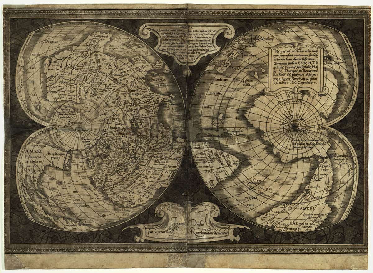
Double Cordiform Map Projection
This 1538 map was created by Flemish cartographer Gerardus Mercator (1512–94). It is the first map to show North America and South America as two separate continents.
Bonne Map Projection
Although named for French cartographer Rigobert Bonne who lived in the 18 century, the Bonne map projection had been in use since the early 1500s. Like the Werner projection, this heart-shaped map projection is also pseudoconical equal-area.

Video: Heart-shaped Maps
References
Brotton, J. (2013). A history of the world in twelve maps. New York: Viking, published by Penguin Group (USA) LLC.
Posch, M. 2011. Appendix C The Stabius-Werner map projection. CCE Status Report 2011.
Snyder JP. 1987. Map projections – A working manual. U.S. Geological Survey Professional Paper 1395. United States Government Printing Office, Washington DC, 383 pp
This article was originally published on February 10, 2016 and has since been updated.
See Also
Fonte : National Geographic

: “Creazione del valore oggi ha bisogno di nuovi meccanismi e imprenditori”")
: “Industria acciaio sta lavorando su processo decarbonizzazione”")
: “Progetti offrono risposta creativa a cambiamento climatico”")
: “Epoca di cambiamenti, necessaria nuova generazione di imprenditorialità”")


